The front’s most active directions in recent weeks are Kupyansky, Pokrovsky, Kurakhovsky and Ugledarsky. How they are connected to each other, what is happening at the front and what is the plan of the occupiers – in the material of the military-political observer of RBC-Ukraine Ulyana Bezpalko.
In the past week, the Russians managed to occupy perhaps the largest area of Ukrainian territory since the beginning of this year. The epicenter of the heaviest fighting is the southern part of the Donetsk region. There is still no talk of the collapse of the Ukrainian front. Furthermore, the situation is not equally critical in all areas.
But in several directions at the same time – Kupyansky, Pokrovsky, Kurakhovsky and Ugledarsky – the creeping advance of the enemy continues and does not slow down. In addition, there is a threat that the enemy may become more active in another – now relatively stable – area.
Northeast
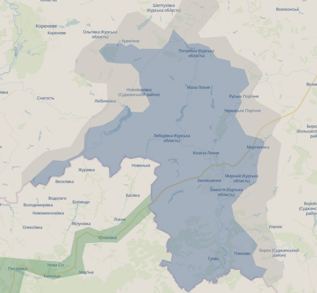
Since mid-October, there have been no significant changes in Kursk operational zone didn’t happen. Within the limits of their counteroffensive, the enemy was able to push our units from the area of Korenevoy and Snagosti towards Novoivanovka. Our military is trying to carry out counterattacks there. At the same time, the Russians want to push Ukrainian units east of Sudzha. After the liberation of the village of Borki, the enemy was able to enter Russkaya Konopelka, but failed to try to capture Plekhovo.
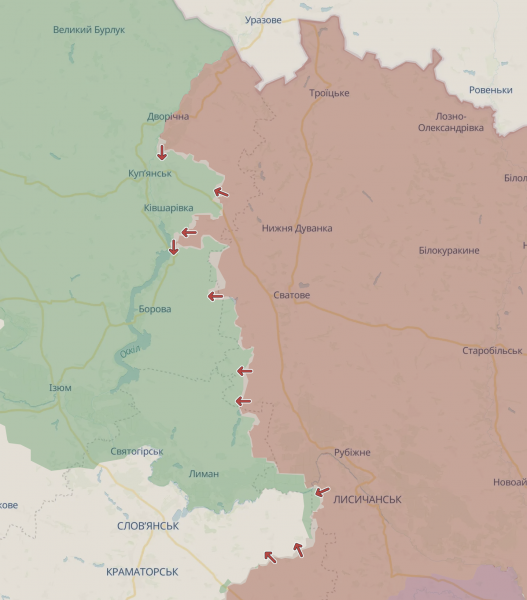
Kursk bridgehead and Kupyansk direction (map: DeepState)
It seems that the enemy’s plan is to compress the bridgehead of the Ukrainian Defense Forces to the Sudzha-Sumy road from various directions. This goal is still a long way off – the Russian counter-offensive is moving rather slowly. And it seems that this is a deliberate plan: to advance faster, Moscow has to take additional troops from elsewhere, thereby sacrificing the offensive there, and it clearly does not want to do this.
In the Kharkov direction near Liptsy and Volchansk, the situation is also without significant changes. When you are in the area Kupyansk The occupiers were able to complete their intermediate task, for which they had been fighting for more than a year – to reach the Oskol River. After the enemy entered the village of Kruglyakovka, our bridgehead on the left bank of Oskol was divided into two parts. This also complicates Borovaya’s position, since the enemy actually cut off the supply route to her, which ran along Oskol from the eastern part of Kupyansk. The Russians are now trying to get to Kupyansk itself from Sinkovka.
If you try to understand the logic of the enemy’s actions, he does not yet need the occupation of the Kharkov region or Kupyansk itself. Perhaps he does not even plan to cross Oskol in the future, through which almost all crossings have been destroyed. But instead it will move south. The Russians need a bridgehead on the left bank of the river to occupy the northern part of the Donetsk region. In particular – Liman, Seversk and the town of Slavyansko-Kramatorsk. And the Oskol River will be able to protect them from a flank attack from the west by Ukrainian troops. It is a very possible scenario in the future we should expect the revival of the enemy in the Liman and Seversky directions.
Northern part of Donbass
In the area Chasovogo Yar there is a tendency for the situation to worsen. Within the city, the progress of the occupiers has long been impeded by the Seversky Donets – Donbass canal, which divides it into west and east – a smaller part from north to south.
However, the Russians chose their traditional tactic – bypassing cities from multiple directions to engage as little as possible in urban combat and force our military to retreat on its own under threat of blockade. In mid-October, the enemy was able to advance north of the city, where he partially captured the Oktyabrsky microdistrict, located on the western bank of the canal.
At the same time, the enemy broke through the canal south of the city – where the reservoir crosses the T0405 (H-32) highway, and in the future they are trying to move along this road. In case of loss of control over Chasovoy Yar, the next target of the occupiers in this direction will be the city of Konstantinovkawhich is also located on the N-32 and is an important logistics hub for our forces in the Donetsk region.
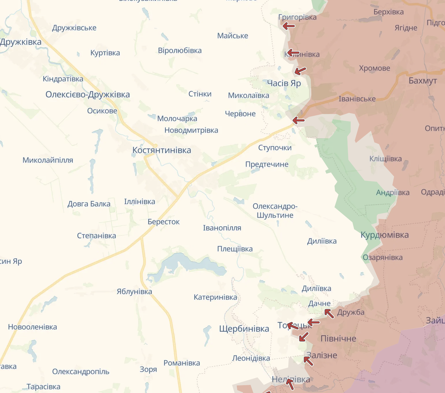 Chasovoy Yar and Toretsk area (map: DeepState)
However, the active advance of the Russians here in the south is still limited by the fact that our military continues to hold the area in the Klishchievka area – this creates a threat for the enemy to attack from the flank.
The enemy’s advance along the N-32 increases the threat to everything Toretsky Defense Region. In recent days, Ukrainian units have managed to restore positions inside Toretsk after the enemy was able to break through in the center. The Russians were pushed back to the eastern part of the central part of the city. It is likely that if we lose control of this city, the occupiers will also develop movement in the direction of Konstantinovka.
The southern part of the Donetsk region and a new threat
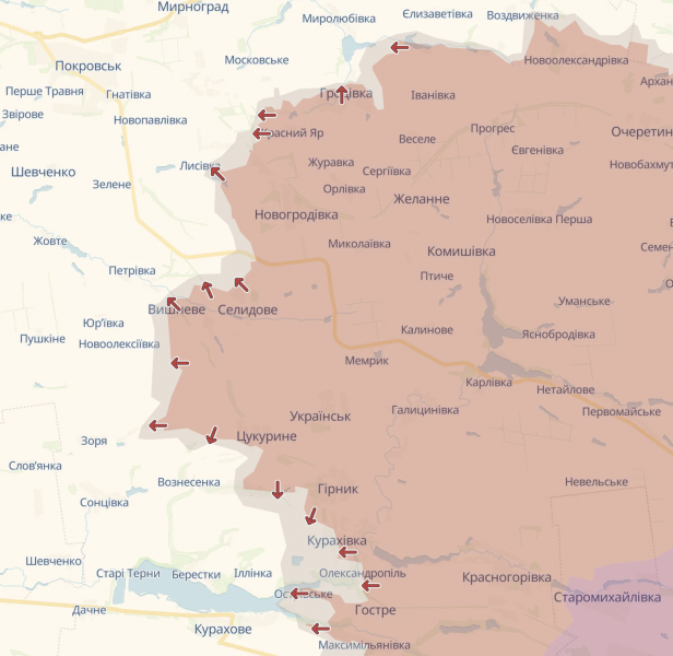
In the near future, the occupiers may resume an intensive offensive against Pokrovsk. They became active again on the Novogrodovka-Grodovka section, east of the city, probably to develop movement in the direction of Mirnograd.
Apparently, the enemy was able to completely occupy the town of Selidovo in the Pokrovsky direction, which created a threat of encirclement of our troops there. After its occupation, the Russians will develop an offensive in the direction of Pokrovsk itself – or rather, to cover it from the south.
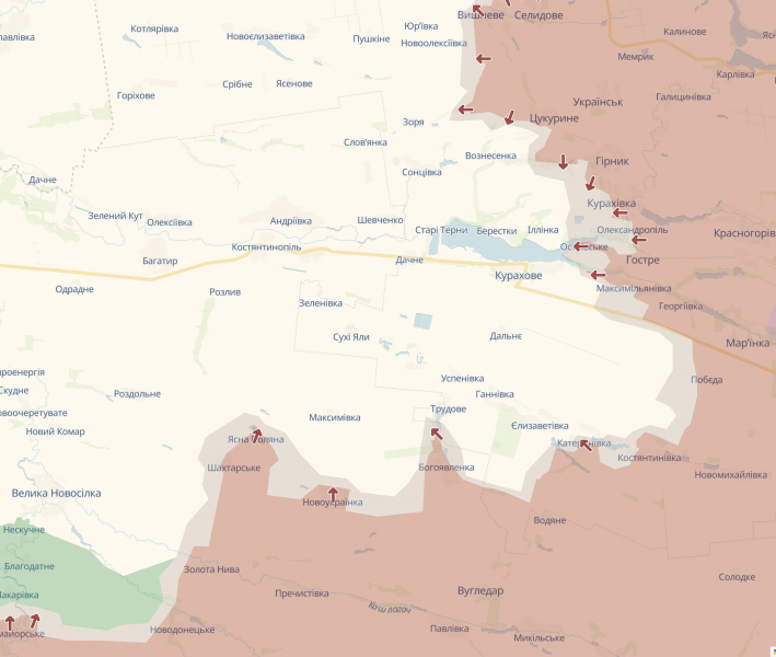
At the same time, the loss of control over Selidov worsened the position of our units holding defenses south – north of the Kurakhovsky reservoir. The occupiers are trying to drive the Ukrainian military away from there to create the conditions for an attack against Kurakhovo – another logistics center for our forces in the south. There is a high probability that in the near future our units will actually have to withdraw at least beyond the line Izmailovka – Kurakhovka – Ostrovskoye to avoid a blockade. The enemy had also already approached Kurakhovoy close from the east, from Maximilian’s side.
Directions Pokrovskoe, Kurakhovskoe and Ugledarskoe (map: DeepState)
The situation for this city was worsened by the fall Guidesfor now the invaders come to Kurakhovo not only from the north and east, but also from the south – from a number of villages on the Shakhterskoye – Ekaterinivka section. All these settlements are located north of Ugledar at a distance of up to 10 kilometers – this is exactly the depth to which the enemy managed to advance after occupying the city in early October. The loss of Kurakhovy could jeopardize the nearby direction in the southern Donetsk region – the Velikaya Novoselka area.
However, another threat may arise in the south in the near future. Several interlocutors in military and political circles fear that the occupiers may launch offensive actions within the Zaporozhye region. The theoretical attack directions are Gulyaypole, Orekhov, and Kamenskoye, where attacks by enemy DRGs have become more common recently. The possible goal of the Russians is an attempt to advance at least 30 kilometers inland to get closer to Zaporozhye and move our troops away from Energodar and Zaporizhia NPP, and then start negotiations from an ultimatum. Our military is preparing to counter such a scenario.
***
Now for Ukraine is perhaps the most critical period in the war. Against the background of fatigue or preoccupation of partners with their own problems, no one can help us better than ourselves. The Russians are now fighting at the peak of their fighting ability. And their further advancement or halt depends, first of all, on whether the Ukrainian Armed Forces can solve the problems that prevent them from not only stopping the aggressor, but also conducting an effective defense. Starting from demotivation and lack of personnel, insufficient coordination between units and construction of fortifications, and ending in places with ineffective lower and mid-level management.
.
